|
|
Track and Access information
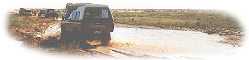
Rain can make tracks impassable, stranding travellers.
Official closure of tracks and public routes occur throughout the year due to local rain.
How to Obtain Track Status
The areas covered by travelling members of the FWDSA is vast, and FWDSA does not attempt to duplicate what others are already performing in terms of advising road/track conditions. Rain is a major factor in causing track closure (and stranding) - be informed and be prepared for all weather conditions, and make yourself aware of safety precautions for remote travel.
Please always check for up-to-date information before travelling on 4WD tracks and public roads in the Flinders and outback. Even small amounts of rain can make outback roads impassable so always be prepared and have at least a week's worth of extra supplies in case of stranding. Severe fines can apply for driving on closed roads.
Regular up-dates are available from the following:
PARKS SA
Roads within national parks and conservation reserves are managed by the Department of Environment, Water and Natural Resources, who provides regular, current information about road conditions and closures via Parks SA:
DPTI Northern Road conditions
Public roads (sealed and unsealed) are managed by the Department of Planning, Transport, and Infrastructure (DPTI) and they provide regular, current information about road conditions and road closures via
Public Access Routes
Public access routes are not roads or part of the formal road network. They are unimproved and unsurfaced dirt tracks intended to provide four wheel drive access in dry conditions only.
Signposted public access routes (PARs) on pastoral stations are managed by the Pastoral Board and are the only tracks on properties that can be accessed without permission from the land manager. Access to other tracks on stations must be made by application to the Public Access Officer.
Australian National Four Wheel Drive Radio Network
Internet: vks737.radio
Road closures for South Australia are regularly broadcast through the VKS 737 network each afternoon (check their site for times/frequencies). Along with any other important road conditions. Their internet site also includes park and track closure information (especially for S.A., and Canning S.R.), and links to relevant internet sites which can provide local details or local telephone contacts. Take note of telephone contacts for the areas you intend to visit.
Safety In The Outback
Natural Resources SA (Arid Lands) has an outback safety page.
Parks SA Remote area travel information (brochure)
Woomera Prohibited Area
The WPA (127,000 square kilometres) is declared under the Defence Force Regulations as a Prohibited Area.
Tourists must have a Tourist Permit (see Forms) issued by the Woomera Test Range before accessing any part of the Woomera Prohibited Area (WPA) except the:
-
Stuart Highway
-
Lake Cadibarrawirracanna Road (Public Access Route)
-
Olympic Dam Highway (B97)
-
William Creek Road
-
Woomera Village.
Permits are required for all other roads. This includes the Anne Beadell Highway, a 4WD track from Coober Pedy to Western Australia.
Permits are required for each vehicle in the party and cannot be issued more than 12 months in advance.
Tourists must also provide at least 10 business days notice to confirm any proposed entry under their permit. Applications should be submitted to the Woomera Test Range in advance of this time to allow for processing.
Anyone entering the WPA must also observe the WPA safety precautions.
Access to the Woomera Prohibited Area (WPA) is subject to exclusion periods during which the Department of Defence may undertake testing of war materiel. For safety and security reasons, designated zones within the WPA will be closed and you are required to evacuate the area during the notified exclusion periods.
In accordance with the Review of the Woomera Prohibited Area final report, Defence is required to advise non-Defence users in March of the WPA Amber Zone exclusion periods that apply for the coming financial year. Amber refers to periodic exclusion, and thus effects 4WDers.
For Access Permit Forms visit forms page at Woomera Prohibited Area Coordination Office and for exclusuon dates the exclusion page.
Permits
To divert from public roads, much of South Australia's outback requires either one or more of Pastoral leasee, Aboriginal council, National Parks, or Commonwealth approval to do so. A further complication are the interests of oil/gas/mining exploration companies who may control leases.
If you believe that you have been unreasonably denied access to a pastoral lease, please pursue this via the FWDSA and/or your local member of parliament.
The Royal Automobile Association of South Australian (RAA) provides maps (that can be purchased at a reduced price by its members or can be purchased full price by non-members) - "Flinders Ranges & Outback" version is useful. These indicate general “permission required” areas. Additional town maps in the areas can be downloaded as PDFs from www.raa.com.au (seach for "map"). Sufficient time must be provided when planning trips to obtain these permissions (with no certainty they will be provided).
A number of publications aimed at the 4WD traveller list addresses for seeking permission. Also, if you are a member of a FWDSA club, your Trips Coordinator will have contacts for leasees.
Please note that some National Parks charge $6 (or more) entrance fee for daily visits, which is being confused with a camping fee. Make sure you check carefully to cover yourself. The Desert Parks Pass is required for crossing the Simpson Desert and some other remote parks.
Heading Outback - Do I Need a Permit? - Can I drive that track?
Please read the introduction on our page Heading Outback - Do I Need a Permit? - Can I drive that track?
Minimum Impact Camping & Touring Guide
A 16 page booklet, prepared by the Natural Resources Advisory Unit, has been distributed to all members in 1998. If you would like a copy, please contact your club delegate, or the Association.
Read more...
SA Track Updates
The following tracks have not been open for public access for sometime now:
-
Chambers Gorge, Flinders Ranges - there is a track open from Wirrealpa/Balcanoona Road to the Western end of the gorge, about 8 km, but vehicular access is not permitted past this point.
-
Along the East/West or Trans Australia Railway corridor, between Lyons and the WA/SA border. The track from Glendambo West to Lyons can be legally used.
-
Along the (new) Ghan or Central Australia Railway corridor, apart from the Stuart Hwy itself where it runs close to the rail corridor.
-
Sacred Canyon (Flinders Ranges) is closed unless on an accredited tour.
If in any doubt about outback tracks in SA consult the RAA Outback Map. If the track is not on this map its not open for public access.
Please check with local bodies, road authorities, or national parks prior to travelling and stay aware of weather forecasts. This site does not repeat the information available from those authorities noted above.
Kati Thanda-Lake Eyre National Park National Park
Information status (pdf file) on the lake (eg birdlife, water coverage or not) can be dowloaded from the NPWS site.
Internet: Desert Parks Bulletin for safety advice and the latest track that covers Lake Eyre, Simpson Desert, Innamincka etc.
Park Closures or Alerts: www.parks.sa.gov.au/know-before-you-go/closures-and-alerts
There are two access tracks to the lake. One, a Public Access Route (PAR) goes North from Marree, through Muloorina station (94km) to Level Post Bay (as at June 2020, closed until further notice); the other turns off the Oodnadatta track 7km south of William Creek (64lm) to Halligan Bay. Good views can also be obtained of Lake Eyre South from the Oodnadatta track where the lake joins the road 90km west of Marree.
PERMITS: See PARKS SA fees. A permit is required if you are actually entering the National Park. Vehicle Day Entry (6:00 AM to 11:00 PM) is $11. Halligan Bay Point camping is $12.50 per night for 2 adults (as at June 2020).
Note that most parks require online booking, however certain passes can be purchased in person from various "outback" locations - see this map at Parks SA. Parks SA offer also a Desert Parks Pass and a Multiple Entry Pass.
Witjira National Park, Simpson Desert
This park is closed in Summer due to extreme heat that may occur.
Please check for latest conditions before you go to these areas. These areas require a Desert Parks pass or a day pass, and can be obtained from the same sources. Local rain or flooding of river and creek sytems can result in closue.
Sand Flag Requirements
Mandatory vehicle flags commenced with the opening of the Simpson Desert on 16th March 2014. Read initial details in our FWDSA KIT Number 15.doc or the current details at National Parks.
Innamincka Region Reserve
Day and/or camping passes are required.
Please check with NPWS for latest conditions.
Further detailed information see the Desert Parks Bulletin or contact the Rangers Office at Innamincka on (08) 8675 9909.
Kudriemitchie Outstation (about 20km from Coongie Lakes) is available for members of affiliated Clubs to use (for a nominal $1 per night!). The building has been maintained by the Toyota Landcruiser Club, South Australia. Being right next to the NW Branch of the Cooper Creek, it provides a location for canoeing, fishing and relaxing. It contains several rooms, a kitchen, a flyproof verandah, short drop toilet. For more information checkout www.tlccsa.asn.au/kudriemitchie.php. Kudriemitchie Outstation may not be reachable if the Coongie Lakes track is closed.
REMEMBER ALL SAFETY PRECAUTIONS WHEN TRAVELLING IN REMOTE AREAS.
Pay for use 4WDing in the Flinders Ranges
Please refer to our Pay for use 4WDing page.
|